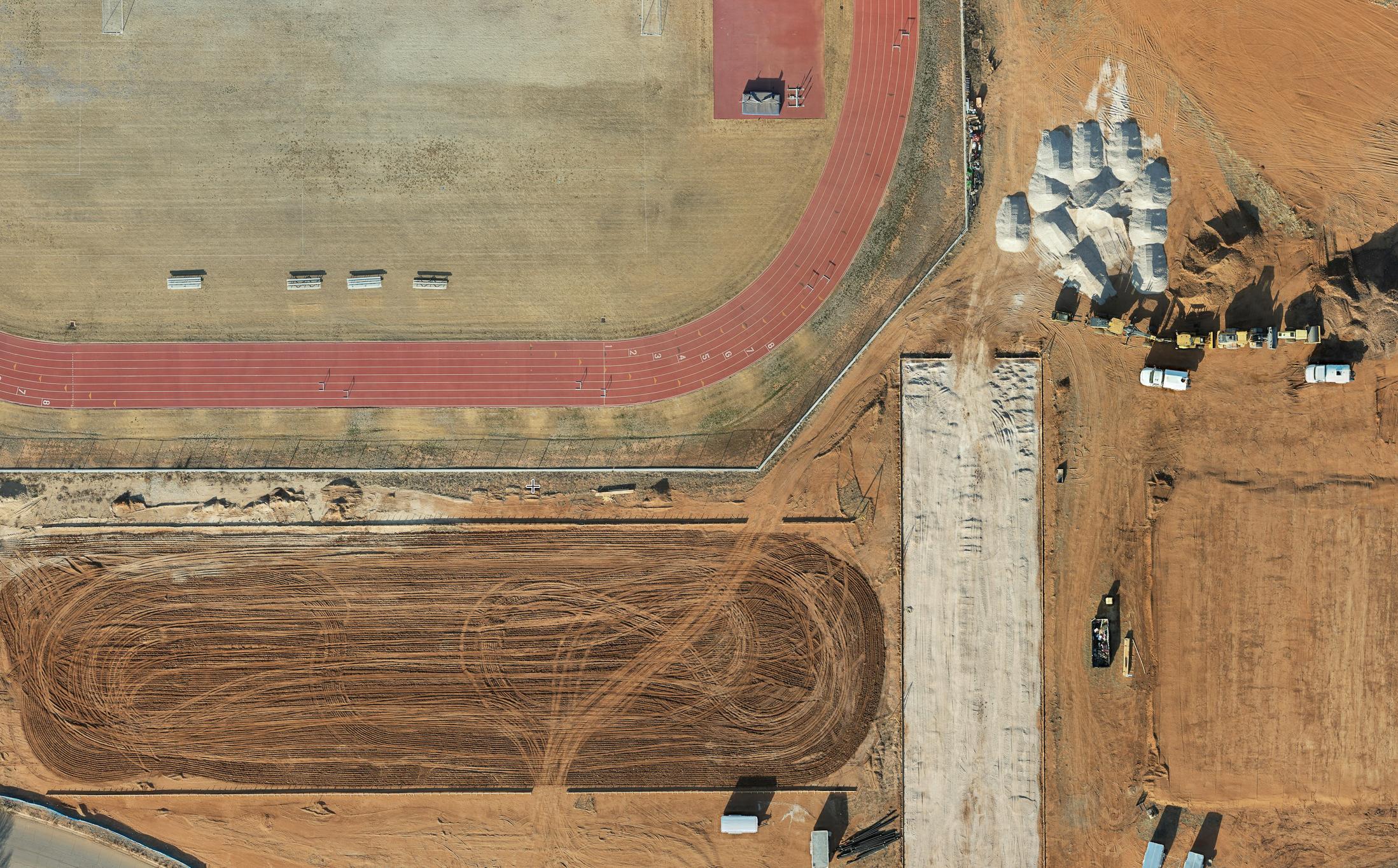
A Smarter Way to See Construction Progress
For builders across West Texas, documenting construction progress accurately is essential. Clients, investors, and project managers all rely on consistent updates that show how a project is moving forward.
Traditional methods—manual photos, ground surveys, and spreadsheets—can’t always capture the full picture. That’s why more builders are turning to drone orthomosaic mapping, a precise aerial imaging technique that delivers measurable, high-resolution maps of construction sites.
With each flight, builders gain a clear, detailed, and data-driven view of every phase of their project.
What Is Drone Orthomosaic Mapping?
Orthomosaic mapping combines hundreds of high-resolution aerial images into a single, seamless, and georeferenced map.
Each drone flight captures overlapping images of the site from multiple angles. Specialized software then stitches these images together to create a detailed 2D map that can be zoomed, measured, and compared over time.
Unlike standard aerial photography, orthomosaic maps provide survey-grade accuracy. Builders can measure distances, calculate volumes, and detect even minor changes on-site — all from their desktop or tablet.
How Builders Use Orthomosaic Maps for Progress Documentation
Orthomosaic mapping provides a visual timeline of construction. By capturing consistent aerial surveys throughout the build, builders can document every phase with precision.
Here’s how it helps:
-
Track development visually: Compare site conditions week by week or month by month.
-
Measure and verify progress: Confirm foundations, utilities, and structures match plan dimensions.
-
Document compliance: Keep an accurate record for permits, inspections, and safety requirements.
-
Share with clients: Provide clear, high-resolution maps that show exactly what’s been accomplished.
This transparency not only builds client trust but also supports better project management and accountability.
Reducing Errors and Saving Time
Traditional documentation often involves manual surveying and scattered photos. Orthomosaic mapping simplifies that process.
Each map offers a full view of the site—accurate to within centimeters—so teams can measure, inspect, and verify without setting foot on the ground.
By identifying potential issues early, builders can avoid costly rework, streamline communication, and maintain tighter control over deadlines.
With drone mapping, every update is faster, safer, and more precise.
Enhancing Client Communication
Clients love seeing progress in a clear and visual way. Orthomosaic maps make it possible to show real-time progress instead of just explaining it.
Builders can overlay current maps with past versions, giving clients a transparent view of how far the project has come. These visual updates reduce uncertainty and demonstrate professionalism — key to maintaining strong client relationships.
Integrating Orthomosaic Data into Project Management
Orthomosaic mapping also integrates easily into project management systems, engineering tools, and planning software.
Builders can:
-
Export site measurements directly to CAD or BIM programs
-
Compare “as-built” data to design plans
-
Track material movement and site logistics
-
Support coordination between contractors, engineers, and clients
This integration streamlines the entire construction workflow, keeping everyone informed and aligned.
How South Plains Aerial Imaging Supports Builders Across West Texas
At South Plains Aerial Imaging, we help builders document progress with precision and professionalism. Our drone orthomosaic mapping services deliver accurate, high-resolution data tailored to each site’s unique needs.
We provide:
-
Orthomosaic maps and elevation models
-
Consistent flight scheduling for ongoing documentation
-
Visual progress reports designed for client sharing
-
Safe, FAA-compliant flight operations
From start to finish, our aerial mapping gives builders the confidence and clarity they need to move projects forward efficiently.
The Future of Construction Documentation
Drone orthomosaic mapping is quickly becoming a standard in modern construction. It replaces guesswork with data and transforms progress documentation into a visual, measurable record.
For builders who want better accuracy, transparency, and communication — this technology is the next step forward.
Ready to Document Your Projects with Accuracy?
Contact South Plains Aerial Imaging today to schedule your next drone orthomosaic mapping session and see how data from above can transform your progress tracking.
📞 806-502-4365
📧 info@spairimaging.com
🌐 southplainsaerialimaging.com

