Aerial Inspection
South Plains Aerial Imaging provides professional drone inspections in Lubbock, West Texas, and throughout the Texas Panhandle. Our FAA Part 107 certified pilots conduct aerial inspections for roofs, building facades, construction sites, and other critical infrastructure. This ensures you receive precise, actionable data for your projects.
By using advanced drone technology, we enhance safety and reduce risk. Additionally, drones complete essential inspections quickly and efficiently. Therefore, our services are ideal for real estate evaluations, insurance assessments, construction monitoring, and commercial property inspections.
Schedule your professional drone inspection today with South Plains Aerial Imaging. You can ensure your property, construction site, or commercial project is safe, compliant, and fully documented across Lubbock and West Texas.
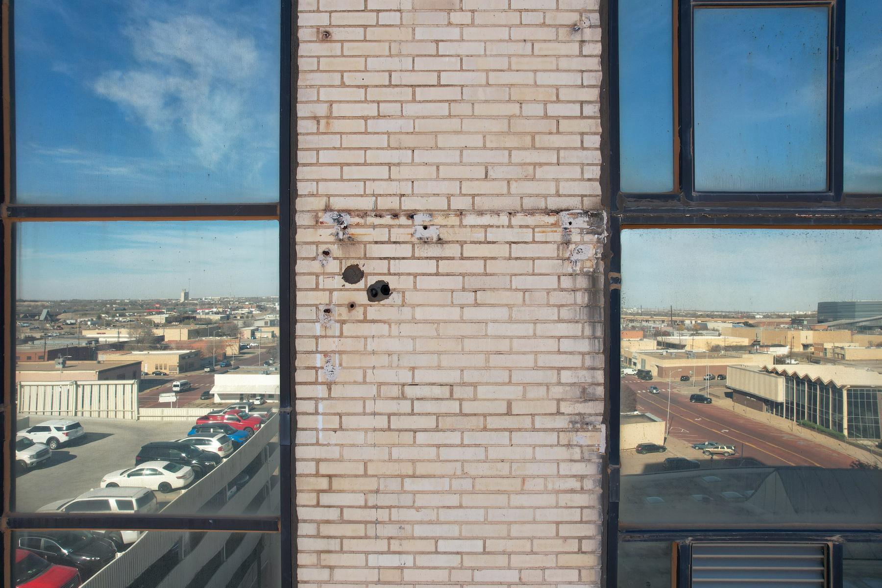
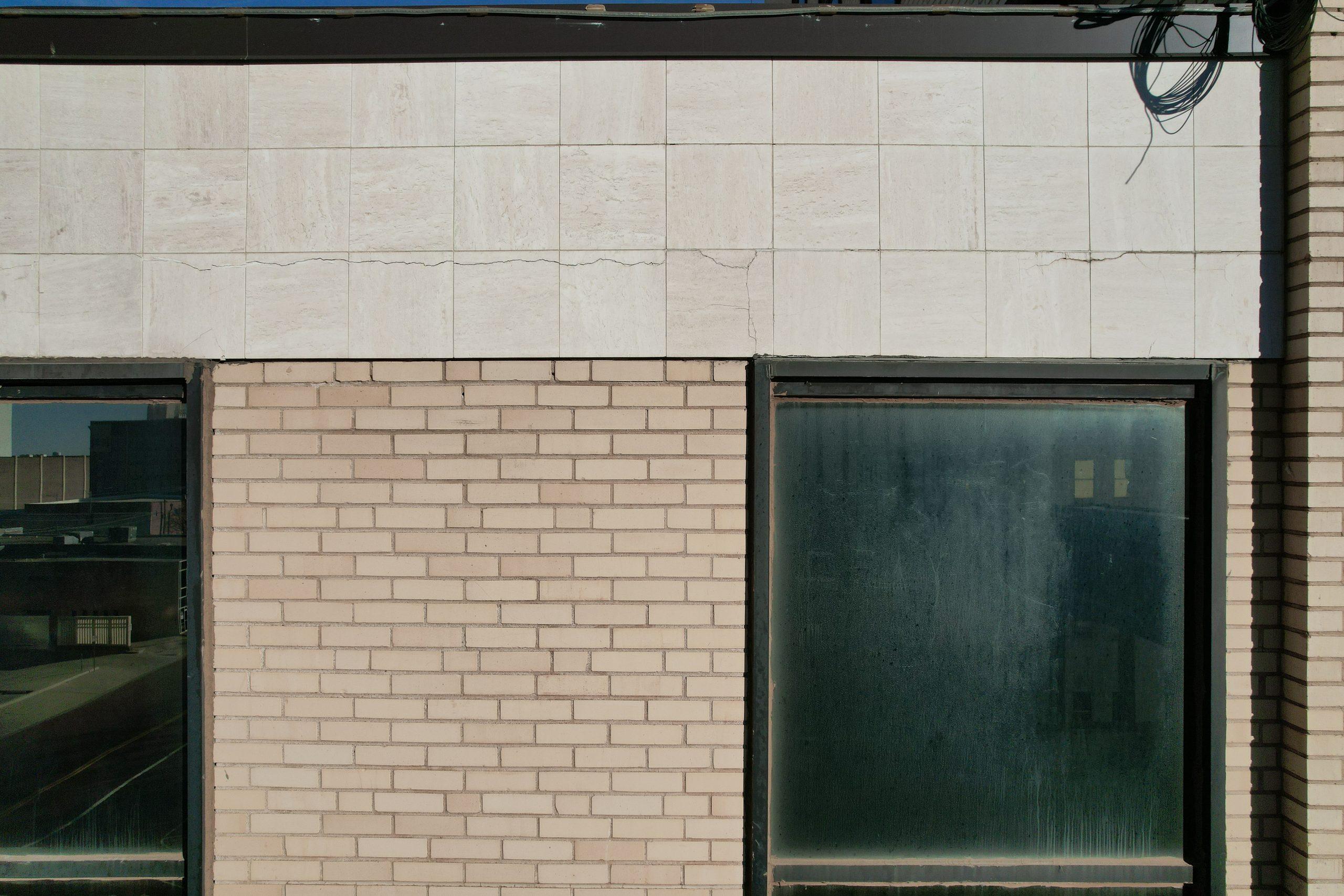
Facade Inspection
South Plains Aerial Imaging delivers professional drone facade and building inspections in Lubbock, West Texas, and across the Texas Panhandle. Our FAA Part 107 certified pilots capture high-resolution imagery to detect cracks, water damage, material degradation, corrosion, and displacement. This allows property owners, managers, and construction teams to identify early warning signs.
Using advanced drone technology, we access hard-to-reach or hazardous areas safely. Consequently, there is no need for swing stages, scaffolding, or rope access crews. This method ensures rapid, efficient data collection with minimal disruption to operations or occupants.
Our drone facade inspections support routine maintenance planning, warranty documentation, regulatory compliance, insurance reporting, and post-storm damage assessment. With detailed visuals and quick turnaround times, you gain actionable insights to maintain your building’s health, appearance, and long-term value.
Schedule your professional drone facade inspection today with South Plains Aerial Imaging. Protect your property with high-resolution aerial inspections across Lubbock and West Texas, providing clarity, precision, and peace of mind.
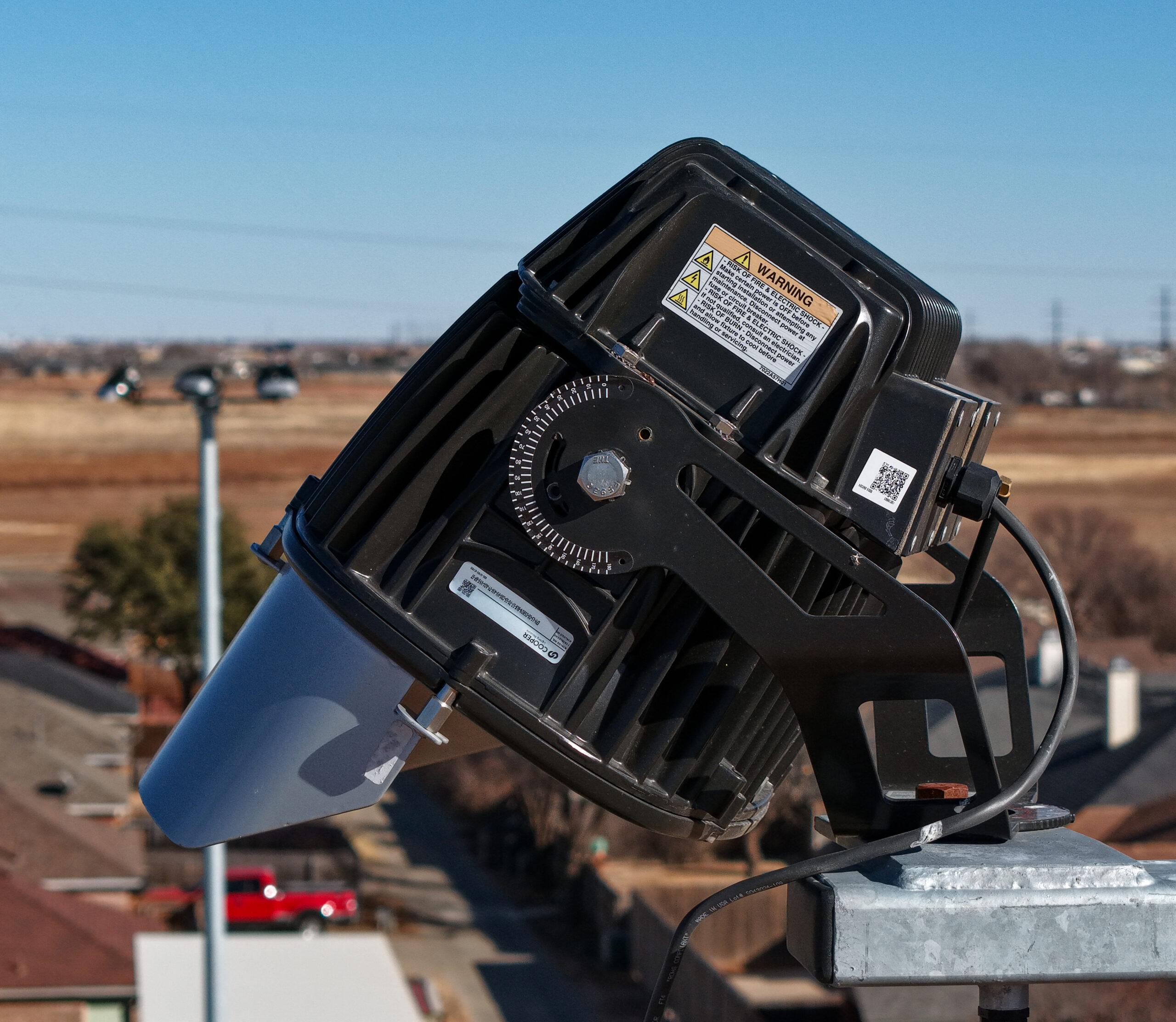
Industrial Inspection
Precision. Safety. Efficiency. From Above.
At South Plains Aerial Imaging, we provide high-resolution industrial drone inspections that help companies across West Texas maintain safety, reliability, and performance in critical infrastructure systems. Our advanced aerial platforms—such as the DJI Air 3S—allow us to capture crystal-clear imagery of hard-to-reach assets without the cost or risk of traditional inspection methods.
Our industrial inspection capabilities include:
-
Power Line Visual Inspections – Identify damaged insulators, corroded hardware, and vegetation encroachment with detailed aerial imagery.
-
Light Pole & Stadium Lighting Inspections – Assess pole alignment, fixture condition, and electrical components safely from the ground.
-
Structural & Facility Inspections – Evaluate rooftops, towers, water tanks, and building exteriors for signs of wear, corrosion, or damage.
-
Wind Turbine & Solar Panel Inspections – Detect cracks, loose panels, or performance issues with precision visual imaging.
-
Industrial Site Documentation – Monitor ongoing construction or maintenance operations with detailed progress imagery.

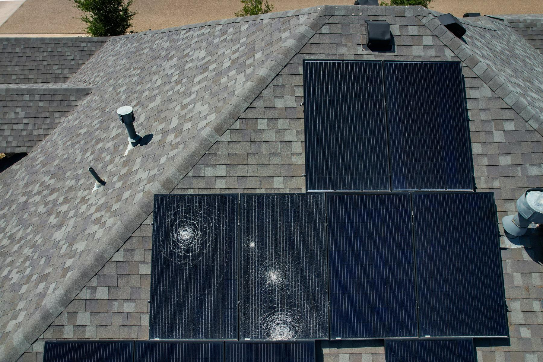
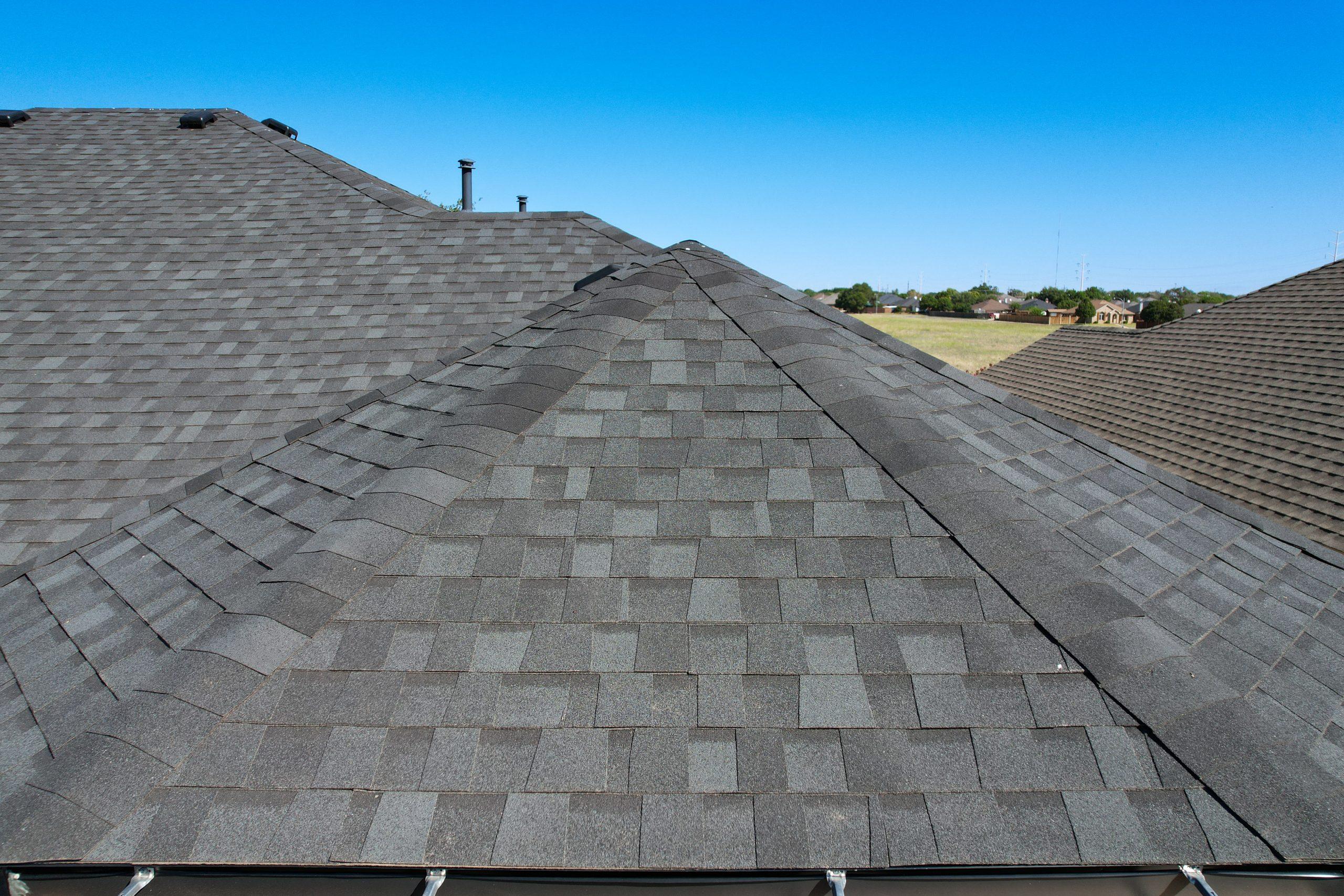
AI-Enhanced Aerial Roof Inspections
South Plains Aerial Imaging provides professional AI-enhanced aerial roof inspections throughout Lubbock, West Texas, and the Texas Panhandle. Our FAA-certified drone pilots capture high-resolution aerial imagery and combine it with advanced AI analysis to generate detailed roof integrity reports that help property owners identify damage, deterioration, and potential maintenance issues.
Using professional drone technology, we safely inspect roofs that may be steep, elevated, or otherwise difficult to access. Our inspections capture comprehensive views of the entire roofing system—including shingles, flashing, valleys, vents, gutters, skylights, and chimney components—without the risks associated with ladders or walking on the roof.
The collected imagery is analyzed to detect common roofing concerns such as:
-
-
Hail damage and impact marks
-
Cracked, lifted, or missing shingles
-
Exposed nails and fastening issues
-
Metal denting on roof vents and flashing
-
Flashing damage and sealant deterioration
-
Mechanical wear or corrosion
-
Debris accumulation and drainage concerns
-
Clients receive a detailed aerial roof integrity report supported by annotated imagery and AI-generated insights. This documentation provides a clear visual record of the roof’s current condition and can be used for maintenance planning, contractor consultations, pre- and post-storm evaluations, property transactions, and insurance discussions.
Benefits Across Industries
Homeowners
Detect roof issues early, avoid costly repairs, and gain peace of mind through professional documentation.
Property Managers
Efficiently monitor multiple buildings and maintain accurate records for long-term maintenance planning.
Roofing Contractors
Use detailed aerial imagery and AI findings to support estimates, proposals, and project planning.
Insurance & Real Estate Professionals
Access time-stamped visual documentation that supports property evaluations and claims assessments.
Schedule your AI-enhanced aerial roof inspection with South Plains Aerial Imaging and receive a safe, efficient, and data-driven assessment of your roof’s condition.


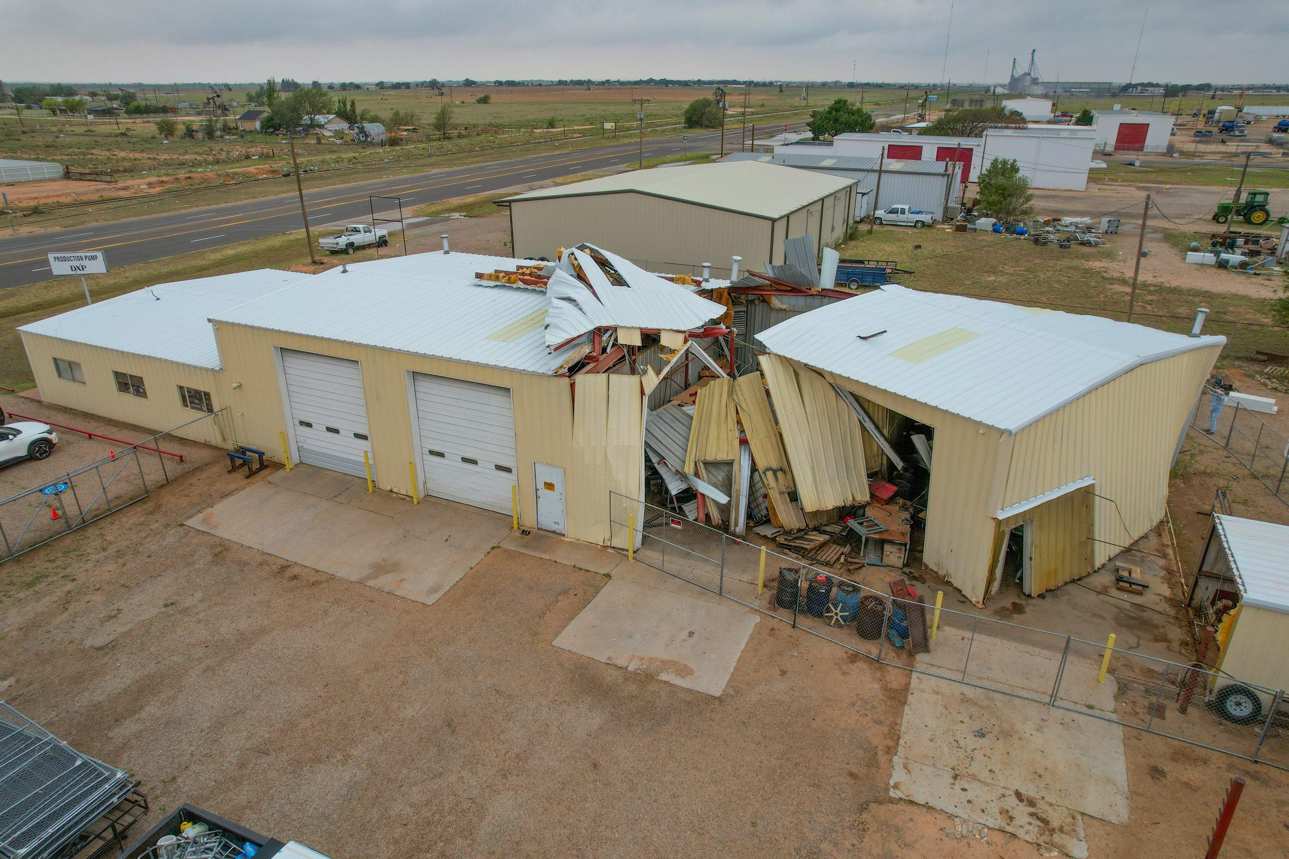
Damage Assesement
South Plains Aerial Imaging provides drone damage assessment services in Lubbock, West Texas, and the Texas Panhandle. Our high-resolution imagery captures damage from hailstorms, fires, high winds, flooding, and other disasters. This allows for fast, accurate evaluations while avoiding the hazards of traditional inspections.
Drones cover large or hazardous areas efficiently, identifying roof impacts, debris patterns, compromised infrastructure, and other critical damage. This non-intrusive approach reduces risk to inspection teams and eliminates the need for ladders, scaffolding, or manual access. Our imagery is perfect for insurance documentation, adjuster assessments, contractor planning, and emergency response coordination.
Our aerial damage assessment services are tailored for:
-
-
Residential neighborhoods: Quick post-storm evaluations for homeowners and insurance
-
Commercial properties: Efficient assessment of structural and facility damage
-
Industrial facilities: Comprehensive coverage of large or complex sites
-
Whether responding to a local storm or a widespread disaster, South Plains Aerial Imaging provides accurate, timely aerial intelligence. This supports fast, informed decision-making.
Schedule your professional drone damage assessment today. Gain high-resolution aerial evaluations across Lubbock, West Texas, and the Texas Panhandle.