Blog
Our Latest News:
Missing Shingles Roof Damage Risks | Protect Your Roof in West Texas
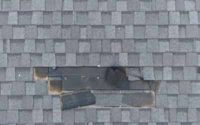
Missing Shingles Roof Damage: What It Means for Your Roof’s Integrity Missing Shingles Roof Damage is one of the most common—and most underestimated—roofing problems faced by homeowners and property managers. While a single missing shingle may not seem like a major concern, it can quickly compromise the integrity of your entire roofing system. At South Plains Aerial Imaging, we provide...
AI Aerial Roof Integrity Reports: The Future of Roof Inspections in West Texas
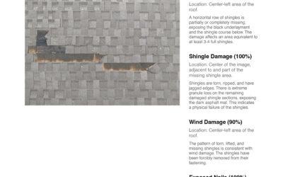
When it comes to protecting your property, AI Aerial Roof Integrity Reports are rapidly becoming one of the most valuable tools available to homeowners, property managers, and commercial building owners. By combining high-resolution drone imagery with artificial intelligence analysis, these inspections reveal damage and wear that traditional inspections often miss. At South Plains Aerial...
Drone Inspections for Historic Preservation: Why Drone Inspection for Historic Buildings Is the Safest Choice
Drone Inspection for Historic Buildings: Preserving the Past Without Risk Historic landmarks connect us to our shared heritage, but maintaining these structures presents unique challenges. Traditional inspection methods often involve scaffolding, lifts, or direct contact—each of which can damage fragile materials. Today, Drone Inspection for Historic Buildings offers a safer, faster, and far...
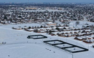
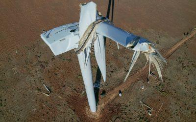
Post–Winter Storm Fern Drone Inspections for Roof, Industrial, and Aerial Assessments
Post–Winter Storm Fern Drone Inspections for Roof, Industrial, and Aerial Assessments, are critical after severe winter weather impacts West Texas. Winter Storm Fern brought freezing temperatures, high winds, ice, and snow. These conditions can damage roofs, industrial facilities, and critical infrastructure. Many issues are not visible from the ground. At South Plains Aerial Imaging, we use...
South Plains Aerial Imaging’s Comprehensive Aerial Photography & Cinematography Methodology
South Plains Aerial Imaging’s Comprehensive Aerial Photography & Cinematography Methodology is built around a disciplined, end-to-end process. This approach ensures safety, consistency, and exceptional visual quality on every project. From planning to final delivery, each phase is handled with technical precision and professionalism. A Proven Process From Start to Finish At South Plains...
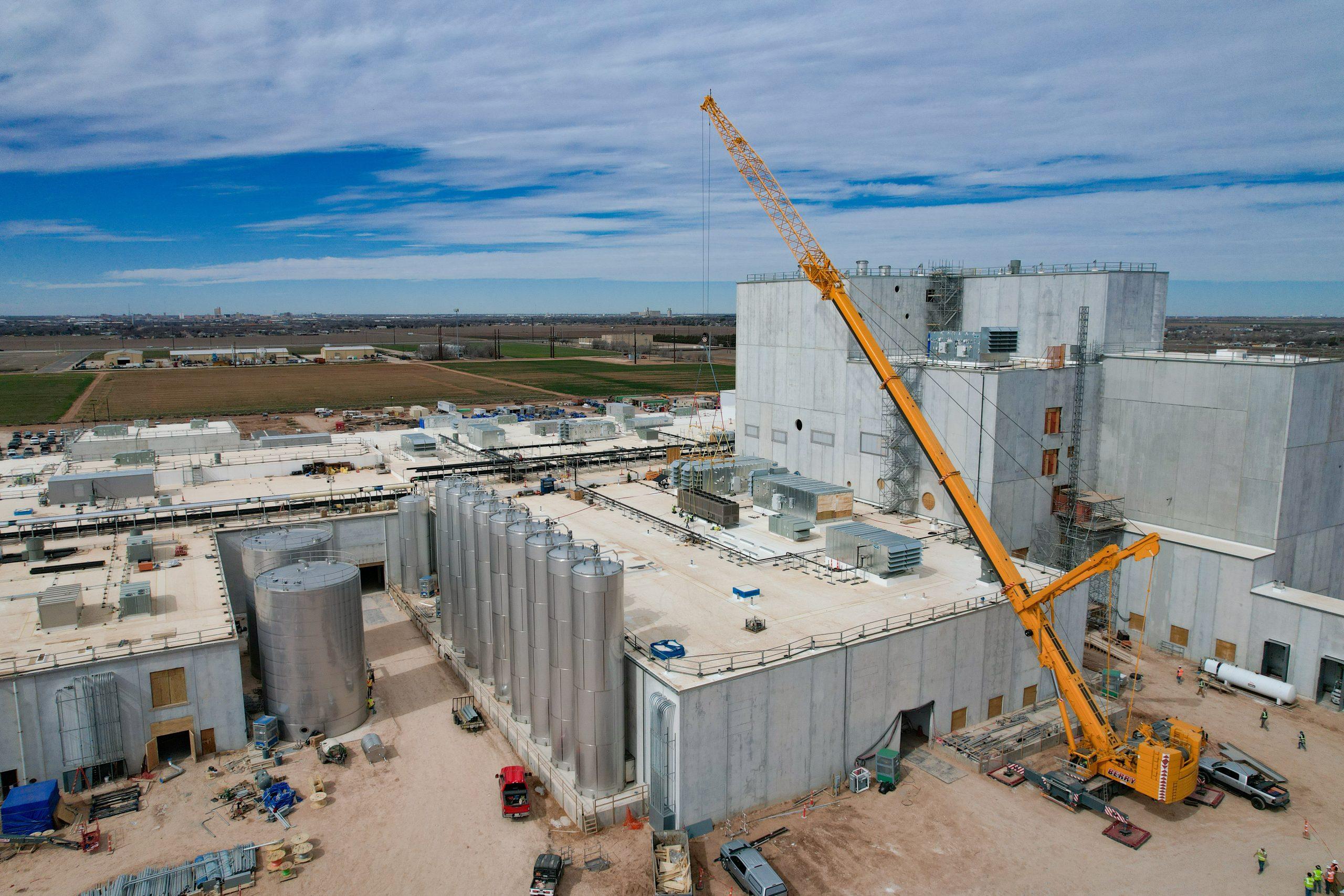
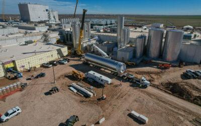
High-Resolution Industrial Inspection Services | South Plains Aerial Imaging
At South Plains Aerial Imaging, high-resolution detail is not just a feature of our work, it is the foundation of our industrial inspection services. When it comes to infrastructure, lighting systems, facilities, and industrial assets, the smallest details often tell the biggest story. Our advanced aerial and elevated imaging solutions are designed to capture those details clearly, accurately,...
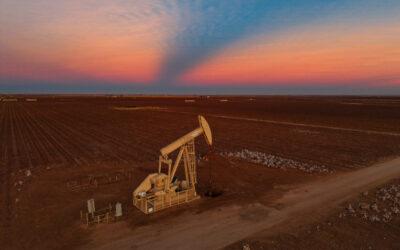
Elevating Perspective: The Power of Aerial Photography for Business Branding
At South Plains Aerial Imaging, we believe that perspective changes everything. The aerial photograph above is a powerful example of how drone imagery can transform an ordinary subject into a compelling visual story—one that resonates with viewers and adds tangible value for businesses across the South Plains. A Story Told From Above This image captures a solitary oil pump-jack set against the...

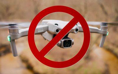
DJI Drones Are Still Legal: What Recent FCC Updates Mean for Our Clients At South Plains Aerial Imaging
At South Plains Aerial Imaging, we believe clear communication and regulatory compliance are essential to professional drone operations. Recent news regarding DJI drones and updates from the Federal Communications Commission (FCC) have raised questions across the industry. This post clarifies recent developments and confirms that our services remain fully operational, and able to provide...

Behind the Lens: What Goes Into a Professional Aerial Shoot
When people see stunning aerial photos or smooth cinematic drone footage, it’s easy to assume the process is simple—launch the drone, capture the shot, and land. In reality, a professional aerial shoot involves careful planning, technical expertise, and a strong understanding of safety and storytelling. At South Plains Aerial Imaging, every project in Lubbock and across West Texas follows a...
Weather Challenges for Drone Pilots on the South Plains (and How We Navigate Them)
Flying drones in West Texas is a unique experience. The South Plains offer wide-open skies, beautiful sunsets, and long lines of cotton fields. However, the weather here can change fast. At South Plains Aerial Imaging, we plan around these conditions to ensure safe and high-quality flights for every project. Below are the most common weather challenges drone pilots face in the Lubbock region and...

The DJI Ban: What It Could Mean for the Future of the U.S. Drone Industry
The U.S. drone industry stands on the brink of one of the most significant regulatory shifts in its history. There is growing political momentum behind the proposed DJI drone ban and new retroactive FCC powers. The potential implications for commercial drone operators, service providers, and the broader unmanned aviation market are profound. While the ban is not yet in effect, the legislative...
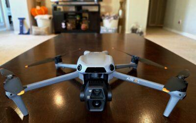
Aircraft Highlight: How the DJI Air 3S Enhances South Plains Aerial Imaging Operations
At South Plains Aerial Imaging, we’re always looking for ways to push the limits of what drone technology can achieve for our clients. Whether we’re conducting detailed industrial inspections, capturing breathtaking aerial photography, or filming cinematic visuals across the South Plains, having the right aircraft makes all the difference. That’s why we’ve added the DJI Air 3S to our...
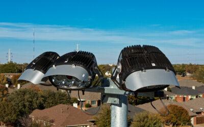
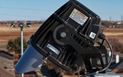
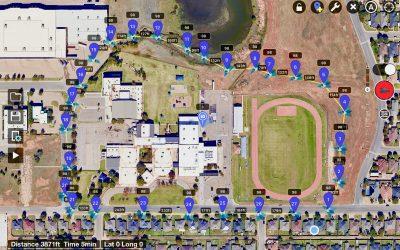
Drones with High-Resolution Cameras Are Essential Tools for Industrial Lighting Inspections
The Growing Need for Precision in Lighting System Inspections Large venues such as sports stadiums and outdoor courts depend on extensive lighting systems. These systems often include tall light poles, complex wiring, many fixtures, and high elevation work. Traditional inspections may require lifts, scaffolding, extended downtime, and manual checklists. Drones with High-Resolution cameras are...
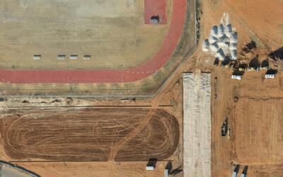
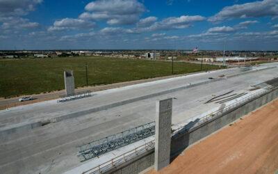
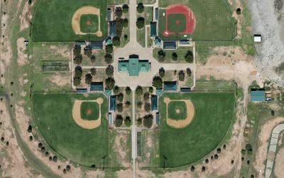
How Builders Use Drone Orthomosaic Mapping to Document Construction Progress
A Smarter Way to See Construction Progress For builders across West Texas, documenting construction progress accurately is essential. Clients, investors, and project managers all rely on consistent updates that show how a project is moving forward. Traditional methods—manual photos, ground surveys, and spreadsheets—can’t always capture the full picture. That’s why more builders are turning to...
Why Aerial Storytelling Works: The Psychology Behind Stunning Drone Visuals
The Power of Visual Storytelling from Above In a fast-paced digital world, visuals tell stories faster and more effectively than words ever could. But not all visuals are created equal. Drone imagery brings a unique and powerful layer to storytelling — one that captivates audiences through height, perspective, and motion. At South Plains Aerial Imaging, we specialize in turning ordinary scenes...
Lubbock, Texas: Aerial Perspectives of a City on the Rise
Lubbock: A City Taking Flight Lubbock, Texas, is experiencing remarkable growth — from expanding neighborhoods and modern commercial developments to revitalized downtown projects and new infrastructure. As the city continues to evolve, drone photography offers a powerful way to capture its transformation from above. At South Plains Aerial Imaging, we take pride in documenting Lubbock’s progress...
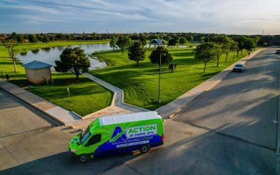
Why Businesses in Lubbock Are Investing in Drone Marketing
In today’s competitive marketplace, businesses in Lubbock and across West Texas are looking for new ways to capture attention, tell their story, and connect with their audiences. Traditional marketing methods still have their place, but more companies are discovering the power of drone marketing. At South Plains Aerial Imaging, we help local businesses harness the impact of professional drone...
From Sky to Screen: How Drone Content Boosts Social Media Engagement in Lubbock
In today’s digital age, social media is the heartbeat of marketing. Businesses, real estate agents, and organizations in Lubbock, Texas, know that eye-catching visuals are the key to standing out in crowded feeds. But how can you capture attention in a world flooded with content? The answer is simple: professional drone photography and aerial videography. At South Plains Aerial Imaging, we...
How Drone Service Providers Strengthen Communities in Lubbock, TX
Drone technology is more than just capturing beautiful visuals—it’s transforming how communities grow, work, and stay safe. At South Plains Aerial Imaging, we take pride in using drone services to positively impact the Lubbock community and surrounding areas across the South Plains and West Texas. From helping local businesses thrive to supporting homeowners and city planning, drones are...
Elevate Your Brand: The Benefits of Aerial Photography & Videography for Commercial Property Promotion
In today’s crowded market, visuals speak louder than words. At South Plains Aerial Imaging, based in Lubbock, Texas, we specialize in capturing stunning aerial photography and videography to help commercial properties, businesses, and developers elevate their marketing game. 1. Gain Superior Context & Impactful Visuals Aerial perspectives reveal the broader story of a property—its layout,...
How Drone Photography Captures the Beauty of West Texas
How Drone Photography Captures the Beauty of West Texas When most people think of West Texas, they picture wide-open skies, cotton fields, endless horizons, and unforgettable sunsets. But capturing the true scale and detail of this region from the ground is difficult. That’s where drone photography comes in. At South Plains Aerial Imaging, we specialize in using drones to showcase the unique...
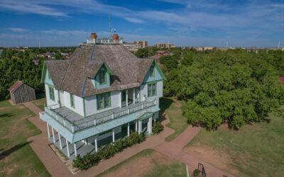
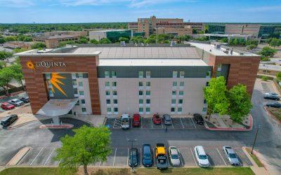
Experience Comfort and Convenience at The Woodrow House Bed & Breakfast in Lubbock, TX
Lubbock Texas is hiding a Gem! Experience the Charm of the Woodrow House Bed & Breakfast Looking for a quiet weekend getaway or a comfortable stay near Texas Tech University? The Woodrow House Bed & Breakfast in Lubbock, TX offers the perfect blend of luxury, convenience, and classic West Texas hospitality. Located directly across from Texas Tech University, the Woodrow House features...
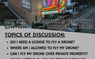
Drones in Your Community – Free Public Event in Lubbock
Drones in Your Community – Free Event in Lubbock At South Plains Aerial Imaging, we’re more than just a drone company. We’re proud to serve Lubbock and contribute positively to our community. This May 5th, we invite the public to a FREE event: Drones in Your Community. What You’ll Learn The role of the drone industry in the United States Common questions about drone operations The benefits of...
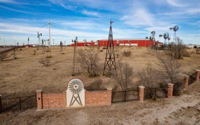
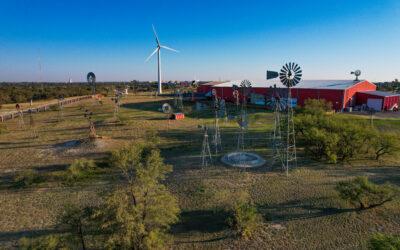
Discover the American Windmill Museum in Lubbock, TX
Discover the American Windmill Museum: A Must-Visit Attraction in Lubbock, TX If you’re searching for unique things to do in Lubbock, Texas, the American Windmill Museum should be at the top of your list. This remarkable attraction is the world’s largest windmill museum, offering visitors a glimpse into the innovation, craftsmanship, and history that shaped agriculture and industry across West...
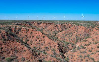
Aerial Drone Filming at Hazel Creek Ranch in Rotan, Texas
Aerial Drone Filming at Hazel Creek Ranch in Rotan, Texas In the heart of West Texas, few properties are as breathtaking as Hazel Creek Ranch—a sprawling 2,862-acre ranch in Rotan, Texas. Featuring diverse topography, abundant wildlife, and sweeping open landscapes, it’s a place that can only be fully appreciated from the air. At South Plains Aerial Imaging, we had the privilege of capturing...
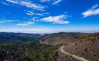
Exploring Cloudcroft, New Mexico – A Hidden Gem in the Sacramento Mountains
Exploring Cloudcroft, New Mexico: Things to Do in the Sacramento Mountains Perched at 8,676 feet in the Sacramento Mountains, Cloudcroft, New Mexico is a picturesque village surrounded by 480,000 acres of pristine forest. This high-altitude destination offers outdoor adventure, charming shops, and historic attractions—making it a favorite getaway for families, couples, and nature enthusiasts. At...
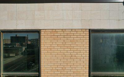
Drone Facade Inspections in Lubbock, TX – Safer, Faster, and More Affordable
Drone Facade Inspections in Lubbock, TX: Safe, Efficient, and Accurate In construction, property management, and building maintenance, safety, efficiency, and accuracy are critical. Traditionally, building facades were inspected using scaffolding, lifts, or rope access—all of which are time-consuming, expensive, and risky. Today, drone facade inspections in Lubbock, TX are changing the game,...
Orthomosaic Drone Mapping in Lubbock, TX – Practical Uses Across West Texas
Orthomosaic Drone Mapping in Lubbock: Practical Applications for Businesses, Communities, and Individuals High-resolution aerial orthomosaic maps are transforming how we plan, document, and interact with the world around us. Unlike survey-grade tools that require pinpoint accuracy, orthomosaic drone mapping focuses on visual clarity and spatial awareness—making it a powerful solution for...
The U.S. Drone Industry in 2025 – Market Growth, DJI Dominance, and Regulatory Challenges
U.S. Drone Industry 2025: Growth, Regulation, and Future Outlook By 2025, the U.S. drone industry has grown from a niche market into a multi-billion-dollar cornerstone of aviation, technology, and public safety. With commercial, recreational, and industrial drones shaping everyday life, UAVs now play a vital role across construction, agriculture, inspections, and emergency response. Explosive...
Autonomous Drones – The Future of UAV Technology and Industry Innovation
Autonomous Drones: The Next Era of UAV Innovation Drones are no longer just gadgets—they’ve become essential tools driving transformation across industries. Among the most revolutionary advancements is the rise of autonomous drones, capable of operating without direct human control. At South Plains Aerial Imaging, we closely track these innovations because they shape the future of aerial...